Executive Summary: Bat Conservation and Sustainable Infrastructure
This report details a study on the flight behavior of the vulnerable barbastelle bat (Barbastella barbastellus) over roads in West Sussex, England. The expansion of road networks presents a significant challenge to achieving Sustainable Development Goal 15 (Life on Land) by causing habitat fragmentation and direct mortality of wildlife. Utilizing innovative 3-D tracking technology, this research provides critical data to inform the development of sustainable infrastructure, in line with SDG 9 (Industry, Innovation, and Infrastructure) and SDG 11 (Sustainable Cities and Communities). The study analyzed 400 flight paths, revealing that 56% occurred at heights posing a risk of vehicle collision. Contrary to expectations, collision risk increased as bats flew closer to canopy cover. These findings suggest that common mitigation strategies, such as planting trees to create “hop-overs,” may inadvertently create ecological traps, undermining conservation efforts. The report concludes that evidence-based approaches, supported by advanced monitoring technologies, are essential for aligning infrastructure development with global sustainability and biodiversity targets.
1. Introduction: Infrastructure Development and Sustainable Development Goal 15 (Life on Land)
The rapid global expansion of road networks is a critical component of economic development but poses a direct threat to biodiversity, challenging the targets of SDG 15 (Life on Land). Roads are a primary driver of habitat fragmentation, genetic isolation, and wildlife mortality. This conflict is particularly acute for species with large home ranges and low reproductive rates, such as bats. The barbastelle bat (Barbastella barbastellus), classified as ‘Vulnerable’ in Europe, is highly susceptible to these pressures due to its long-distance foraging behavior, which increases its encounters with road infrastructure.
Achieving SDG Target 15.5, which calls for urgent action to halt biodiversity loss and prevent the extinction of threatened species, requires a comprehensive understanding of how infrastructure impacts wildlife. Roads act as mortality sinks for many bat species, with vehicle collisions being a significant source of additive mortality that can threaten the viability of local populations. This study addresses this critical knowledge gap by investigating the specific flight behaviors of B. barbastellus at road interfaces, providing data essential for integrating biodiversity conservation into national and local planning, as mandated by SDG Target 15.9.
2. Methodology: Innovative Approaches for Sustainable Infrastructure Planning (SDG 9)
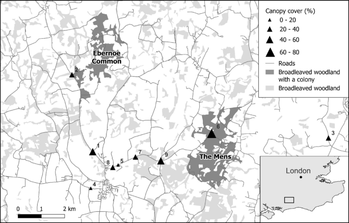
To generate robust data for developing sustainable and resilient infrastructure (SDG 9.1), this study employed an innovative technological approach to monitor bat behavior. The research was conducted at nine road sites in southern England, located near known maternity colonies of B. barbastellus.
2.1. Data Collection and Survey Design
- 3-D Trajectory Reconstruction: Paired near-infrared cameras were used to film road sections from sunset to sunrise. This setup, combined with advanced tracking software, allowed for the precise 3-D reconstruction of bat flight trajectories, providing accurate data on flight height, speed, and orientation.
- Acoustic Identification: A network of static acoustic detectors was deployed at each site to confirm the species as B. barbastellus, ensuring the accuracy of the behavioral analysis.
- Environmental Characterization: LiDAR data was used to create a canopy height model, allowing for the characterization of local vegetation structure (canopy cover, canopy height, distance to canopy) around each flight path.
- Traffic and Risk Assessment: Vehicle traffic density was quantified from video footage. Collision risk was categorized based on flight height, with flights below 5 meters considered ‘unsafe’ due to the maximum height of vehicles in the UK.
2.2. Data Analysis
Statistical models were developed to test hypotheses regarding the influence of environmental and traffic variables on bat flight behavior. The analysis aimed to determine how canopy structure and traffic density affected:
- Mean flight height and collision risk.
- Flight orientation (crossing vs. following the road).
- Flight speed.
This analytical framework provides a replicable methodology for assessing the ecological impact of infrastructure, contributing to the evidence base needed for sustainable planning.
3. Results: Assessing Infrastructure Impact on a Vulnerable Species
A total of 400 flight trajectories of B. barbastellus were reconstructed and analyzed. The findings reveal specific behavioral patterns that have significant implications for conservation and road mitigation design.
3.1. Flight Height and Collision Risk
- A majority of flights (56%) occurred at an unsafe height (below 5 meters), placing bats at risk of collision with vehicles.
- The median flight height was 4.75 meters. While only 1% of flights were at risk from small vehicles (<2m), 55% were at risk from larger vehicles like lorries and trucks.
- Contrary to the study’s hypothesis, increasing distance from canopy cover was associated with an increase in flight height.
- Consequently, greater canopy cover significantly increased the collision risk. For every 10% increase in canopy cover, the odds of a bat flying at an unsafe height increased by 60%.
3.2. Flight Orientation and Speed
- Bats were more likely to follow the road (a behavior associated with foraging) when in close proximity to canopy cover. They were more likely to cross the road directly when further from tree cover.
- Flight speed was positively correlated with canopy cover. Bats flew approximately 0.14 m/s faster for every 10% increase in canopy cover.
- Traffic density had no significant effect on bat flight height, orientation, or speed, suggesting a lack of behavioral avoidance of vehicles.
4. Discussion and Recommendations for Sustainable Development
The results of this study challenge conventional wisdom regarding road mitigation for bats and provide critical insights for achieving a sustainable balance between infrastructure development and biodiversity conservation, directly addressing the aims of SDGs 9, 11, and 15.
4.1. Re-evaluating Mitigation Strategies for SDG 15.5
The finding that increased canopy cover elevates collision risk for B. barbastellus is of profound importance for conservation. It suggests that widely used mitigation measures, such as planting trees to create “hop-overs,” may be ineffective or even detrimental for this species. By encouraging bats to cross roads at lower, more dangerous heights, such schemes could function as ecological traps, undermining efforts to protect threatened species as required by SDG Target 15.5. Conservation strategies must be species-specific and based on empirical evidence rather than generalized assumptions.
4.2. Implications for SDG 9 (Sustainable Infrastructure) and SDG 11 (Sustainable Communities)
This research underscores the necessity of integrating detailed ecological data into the planning and design of infrastructure. To be truly sustainable, infrastructure must minimize its negative externalities on natural ecosystems. The use of 3-D tracking technology represents an innovative approach that can provide the high-resolution data needed to design safer roads and evaluate the effectiveness of mitigation measures. This aligns with SDG 9.1‘s call for quality, reliable, and sustainable infrastructure. Furthermore, protecting biodiversity and natural heritage is a key component of SDG 11.4. By developing infrastructure that better accommodates wildlife, planners can help maintain the ecological integrity that underpins sustainable and resilient communities.
4.3. Recommendations for Policy and Practice
Based on the findings, the following recommendations are proposed to better align road development with Sustainable Development Goals:
- Prioritize Evidence-Based Planning: Road planning and mitigation design must be informed by species-specific behavioral data. The assumption that creating canopy continuity over roads is universally beneficial for bats is flawed and should be reassessed.
- Strategic Siting of Infrastructure: To minimize collision risk for B. barbastellus, new roads should avoid areas with high canopy cover, such as woodlands. Siting crossings in more open areas where bats naturally fly higher should be prioritized.
- Implement Traffic Management Measures: Given that bats do not appear to alter their behavior in response to traffic density, restricting night-time traffic, particularly large vehicles, in known high-activity zones could be a cost-effective measure to reduce mortality.
- Adopt Advanced Monitoring Technologies: The 3-D tracking methodology demonstrated in this study should be more widely adopted for environmental impact assessments and post-construction monitoring to evaluate the true effectiveness of mitigation structures.
- Exercise Caution with Vegetation Management: While reducing canopy cover at roadsides may encourage higher flight, this must be balanced against the potential loss of habitat connectivity. Any vegetation removal should be part of a broader, landscape-scale conservation plan.
Analysis of Sustainable Development Goals (SDGs) in the Article
1. Which SDGs are addressed or connected to the issues highlighted in the article?
The article primarily addresses issues related to three Sustainable Development Goals (SDGs):
-
SDG 15: Life on Land
This is the most relevant SDG as the article’s core focus is on the impact of human infrastructure on a terrestrial species. It examines the threats to the barbastelle bat (Barbastella barbastellus), a ‘Vulnerable’ species, due to road networks. The discussion revolves around biodiversity loss, habitat fragmentation, and the mortality of wildlife, which are central themes of SDG 15.
-
SDG 9: Industry, Innovation, and Infrastructure
The article directly links the expansion of road infrastructure to negative ecological impacts. It critiques current mitigation strategies (like hop-overs) and proposes advanced technological methods (3-D tracking) to better inform the development of more sustainable and wildlife-friendly infrastructure. This aligns with SDG 9’s aim to build resilient, sustainable infrastructure and foster innovation.
-
SDG 11: Sustainable Cities and Communities
The expansion of the road network is a key component of urban and rural development. The article highlights the “negative effects of roads on biodiversity” and the extensive “road effect-zone.” By providing data to inform better road planning and management, the study contributes to making human settlements and their connecting infrastructure more sustainable and reducing their adverse environmental impact on natural habitats, as targeted by SDG 11.
2. What specific targets under those SDGs can be identified based on the article’s content?
Several specific targets under the identified SDGs are relevant to the article’s content:
-
SDG 15: Life on Land
-
Target 15.5: “Take urgent and significant action to reduce the degradation of natural habitats, halt the loss of biodiversity and, by 2020, protect and prevent the extinction of threatened species.”
Explanation: The entire study is dedicated to understanding and mitigating a major threat to the barbastelle bat, which is explicitly identified as a ‘Vulnerable’ species in Great Britain and Europe. The research on vehicle collision risk directly addresses the need to protect a threatened species and halt a specific cause of biodiversity loss. -
Target 15.9: “By 2020, integrate ecosystem and biodiversity values into national and local planning, development processes, poverty reduction strategies and accounts.”
Explanation: The article concludes with “recommendations for managing roadside vegetation and planning new road schemes.” This is a direct call to integrate the findings—representing biodiversity values—into the development process of road infrastructure to mitigate negative impacts on bats.
-
Target 15.5: “Take urgent and significant action to reduce the degradation of natural habitats, halt the loss of biodiversity and, by 2020, protect and prevent the extinction of threatened species.”
-
SDG 9: Industry, Innovation, and Infrastructure
-
Target 9.1: “Develop quality, reliable, sustainable and resilient infrastructure…to support economic development and human well-being…”
Explanation: The article critiques the sustainability of existing road infrastructure by demonstrating its harmful effects on wildlife. The research aims to provide evidence for developing more sustainable infrastructure that minimizes ecological damage, thereby improving its overall quality and resilience in an environmental context. -
Target 9.4: “By 2030, upgrade infrastructure…to make them sustainable…with greater adoption of…environmentally sound technologies and processes…”
Explanation: The study highlights that some mitigation measures (“hop-overs”) may be ineffective or even create an “ecological trap.” It advocates for an evidence-based approach using innovative technology (“near-infrared cameras in combination with 3-D tracking approaches”) to evaluate and design environmentally sound infrastructure solutions.
-
Target 9.1: “Develop quality, reliable, sustainable and resilient infrastructure…to support economic development and human well-being…”
-
SDG 11: Sustainable Cities and Communities
-
Target 11.4: “Strengthen efforts to protect and safeguard the world’s cultural and natural heritage.”
Explanation: The study was conducted near woodlands (The Mens and Ebernoe Common) that are “designated Special Areas of Conservation (SACs).” These protected areas represent natural heritage that is being negatively impacted by the surrounding road infrastructure, and the study’s goal is to find ways to reduce this impact.
-
Target 11.4: “Strengthen efforts to protect and safeguard the world’s cultural and natural heritage.”
3. Are there any indicators mentioned or implied in the article that can be used to measure progress towards the identified targets?
Yes, the article mentions or implies several indicators that can be used to measure progress:
-
Indicator for Target 15.5 (Protecting threatened species):
- Red List Status: The article explicitly states that the barbastelle bat is classified as ‘Vulnerable’ in both Great Britain and Europe. This status, derived from the IUCN Red List, is a direct measure used in the official SDG indicator 15.5.1 (Red List Index). Monitoring changes in the species’ conservation status over time would indicate progress.
-
Indicators for Biodiversity Loss and Habitat Degradation (Relevant to Target 15.5):
- Wildlife-Vehicle Collision Rate: The article quantifies the risk of collision, stating that “56% of flight trajectories occurred at heights that placed bats at risk of vehicle collision.” It also cites other studies that measure mortality as “bat casualties per kilometre per year.” This rate serves as a direct indicator of the negative impact of roads.
- Bat Flight Behavior Metrics: The study uses mean flight height, speed, and orientation (crossing vs. following a road) as metrics to understand bat-road interactions. These can be used as indicators to assess the barrier effect of roads and the effectiveness of mitigation measures. For instance, a higher proportion of bats crossing at safe heights would indicate successful mitigation.
-
Indicators for Sustainable Infrastructure (Relevant to Targets 9.1, 9.4, and 15.9):
- Effectiveness of Mitigation Measures: The study’s methodology is proposed to “evaluate the effectiveness of mitigation in reducing collision risk.” The percentage reduction in flights at unsafe heights after implementing a mitigation measure (like a bat gantry or green bridge) would be a key performance indicator.
- Canopy Cover and Structure: The article identifies canopy cover as a key factor influencing collision risk. The “percentage of canopy cover” and “distance to canopy cover” are used as predictive variables and can serve as indicators for assessing the risk level of existing or planned road sections.
4. Summary Table of SDGs, Targets, and Indicators
| SDGs | Targets | Indicators Identified in the Article |
|---|---|---|
| SDG 15: Life on Land |
15.5: Take urgent action to reduce habitat degradation, halt biodiversity loss, and protect threatened species.
15.9: Integrate biodiversity values into national and local planning and development processes. |
|
| SDG 9: Industry, Innovation, and Infrastructure |
9.1: Develop quality, reliable, sustainable, and resilient infrastructure.
9.4: Upgrade infrastructure to make it sustainable, adopting environmentally sound technologies. |
|
| SDG 11: Sustainable Cities and Communities | 11.4: Strengthen efforts to protect and safeguard the world’s natural heritage. |
|
Source: nature.com


