Executive Summary
This report analyzes the spatiotemporal variations in land use/cover change (LUCC) and habitat quality (HQ) within the Three-River Source Region (TRSR), a globally significant ecosystem critical to achieving the Sustainable Development Goals (SDGs). Utilizing an integrated PLUS-InVEST modeling framework, this assessment covers historical transformations from 1990 to 2020 and provides projections to 2050. The findings are essential for evaluating progress towards SDG 15 (Life on Land) and SDG 6 (Clean Water and Sanitation).
- Over the past three decades, the TRSR has seen a positive trend in land restoration, with grasslands and water bodies expanding by 14,593.43 km² and 1,888.67 km², respectively, primarily through the conversion of unused land. This aligns with efforts under SDG Target 15.3 to restore degraded land.
- Despite these gains, overall habitat quality has declined, with areas of degradation (0.67% of the region) exceeding areas of improvement. This trend poses a direct threat to biodiversity and the achievement of SDG Target 15.5.
- Projections to 2050 indicate a continued expansion of grasslands and water bodies. However, without strategic intervention, habitat quality degradation is forecast to intensify, potentially doubling in spatial extent, further jeopardizing regional sustainability.
- The report concludes that future strategies must prioritize the conservation of grasslands and water systems while implementing targeted management of unused land to support both ecological integrity and the broader 2030 Agenda for Sustainable Development.
Introduction: Aligning Land Management with Sustainable Development Goals
The Global Context: Land Use and the 2030 Agenda
Effective land management is a cornerstone of the 2030 Agenda for Sustainable Development. Changes in land use directly influence ecosystem integrity, biodiversity, and the provision of essential services such as clean water and climate regulation. This investigation frames the analysis of Land Use/Cover Change (LUCC) and Habitat Quality (HQ) within the context of key SDGs, particularly SDG 15 (Life on Land), which aims to protect, restore, and promote the sustainable use of terrestrial ecosystems. Understanding these dynamics is crucial for developing policies that halt biodiversity loss and reverse land degradation.
The Three-River Source Region (TRSR): A Critical Area for SDG Achievement
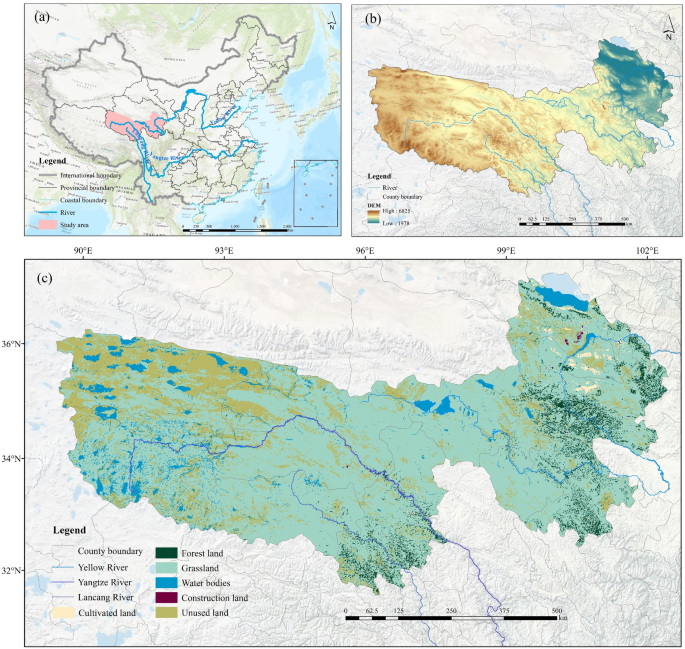
The TRSR is a protected area of immense ecological importance, serving as the headwaters of the Yangtze, Yellow, and Lancang rivers and hosting one of the world’s most biodiverse high-altitude ecosystems. Its health is fundamental to:
- SDG 15 (Life on Land): The region’s vast grasslands and wetlands support numerous protected species and are vital for maintaining biodiversity.
- SDG 6 (Clean Water and Sanitation): The TRSR functions as a “water tower” for China and Asia, making its conservation essential for regional water security (Target 6.6).
- SDG 13 (Climate Action): As a sensitive high-altitude ecosystem, its stability contributes to climate resilience and adaptation.
This report aims to quantify the impacts of land use change on HQ to inform evidence-based strategies that advance sustainable development in this critical region.
Methodology: Integrated Modeling for Sustainable Planning
Data and Modeling Framework
This analysis employs an integrated PLUS-InVEST modeling framework to assess historical and future ecological patterns.
- The Patch-generating Land Use Simulation (PLUS) model was used to analyze historical LUCC (1990–2020) and project future land use patterns for 2050 based on environmental and socioeconomic drivers.
- The Integrated Valuation of Ecosystem Services and Tradeoffs (InVEST) model was applied to calculate a Habitat Quality Index (HQI) for 1990, 2000, 2010, 2020, and the projected 2050 scenario.
All spatial datasets were standardized to a 100m x 100m raster format to ensure consistency and accuracy in the analysis.
Analysis of Findings: Land Use and Habitat Quality Dynamics (1990-2020)
Land Use/Cover Change (LUCC) Trends
Between 1990 and 2020, the TRSR landscape underwent significant transformations, reflecting a trend towards ecological restoration. The most notable changes include:
- Grassland Expansion: Increased by 14,593.43 km², reinforcing its status as the dominant ecosystem.
- Water Body Expansion: Increased by 1,888.67 km², enhancing water resources in line with SDG 6.
- Unused Land Reduction: Decreased by 17,001.35 km², with its proportion of the total area falling from 22.24% to 17.79%.
The primary driver of these changes was the conversion of unused land into grassland, a positive development for achieving SDG Target 15.3 on combating desertification and restoring degraded land.
Habitat Quality (HQ) Assessment and Linkages to SDG 15
Despite positive land restoration trends, the overall habitat quality in the TRSR exhibited a net decline over the 30-year period. This finding presents a significant challenge to the achievement of SDG 15.
- Net Degradation: The total area experiencing habitat degradation (0.67%) was greater than the area showing improvement, indicating a progressive weakening of ecosystem integrity.
- Drivers of Degradation: The most severe HQ deterioration was caused by the conversion of high-quality habitats, such as grasslands and water bodies, into unused land. This directly undermines SDG Target 15.5, which calls for halting the loss of biodiversity and reducing the degradation of natural habitats.
- Spatial Patterns: HQ remains highest in the forested and aquatic ecosystems of the eastern and southern TRSR, while the lowest quality areas are concentrated in the unused lands of the northwest.
Projections and Future Outlook (2020-2050)
Projected Land Use Scenarios
Based on current trends, the PLUS model projects a continued shift towards ecological land cover by 2050:
- Grassland area is projected to increase by an additional 7,671.81 km².
- Water systems are expected to expand by 1,381.34 km².
- Unused land is forecast to contract by a further 8,682.10 km².
This trajectory suggests that ecological restoration efforts, particularly the conversion of unused land, will remain a dominant feature of land use dynamics, contributing positively to the goals of SDG 15.
Future Habitat Quality and Risks to SDG Targets
While land use trends appear positive, the InVEST model projects a concerning future for habitat quality. Without proactive policy interventions, the TRSR is on a path of accelerating ecological degradation.
- Intensified Degradation: The area of degraded habitats is projected to be more than double the area of improved habitats (17,113.30 km² vs. 7,945.8 km²).
- Persistent Downward Trend: This imbalance establishes a persistent downward trajectory in regional habitat quality, creating a substantial risk of failing to meet the conservation targets outlined in SDG 15. The primary threat is the projected conversion of moderate-quality habitats to lower-quality states due to escalating environmental pressures.
Conclusion and Policy Recommendations for SDG Attainment
Summary of Key Findings
The TRSR presents a complex dynamic where successful land restoration (conversion of unused land to grassland) coexists with an overall net degradation of habitat quality. While land use projections to 2050 are encouraging, the forecast for habitat quality is alarming and demands urgent policy action to align regional development with the Sustainable Development Goals.
Strategic Recommendations for Sustainable Management
To reverse the trend of habitat degradation and ensure the long-term sustainability of the TRSR, the following strategic actions are recommended:
- Prioritize Conservation of Core Ecosystems (SDG 15.1, SDG 6.6): Implement and enforce stringent protection measures for existing grasslands and water bodies. These ecosystems are the foundation of the region’s biodiversity and water security and must be safeguarded from conversion and degradation.
- Implement Targeted Management of Unused Land (SDG 15.3): Develop and apply precise, science-based restoration strategies for different categories of unused land. The focus should be on facilitating conversion to ecologically functional grasslands and wetlands while preventing further expansion of degraded areas.
- Integrate Nature-based Solutions (NbS) (SDG 13.1, SDG 15.5): Adopt NbS frameworks in regional planning to enhance the TRSR’s ecological resilience. This includes combining natural regeneration with active rehabilitation to strengthen the ecosystem’s capacity to adapt to climate change and mitigate the impacts of human activities.
- Strengthen Monitoring and Adaptive Management: Continue systematic monitoring of LUCC and HQ dynamics using advanced modeling and field validation. This will provide the necessary data to refine conservation strategies and ensure management practices remain effective and responsive to changing conditions, thereby supporting sustained progress toward the 2030 Agenda.
Analysis of Sustainable Development Goals in the Article
1. Which SDGs are addressed or connected to the issues highlighted in the article?
The article on land use/cover change (LUCC) and habitat quality (HQ) in the Three-River Source Region (TRSR) is primarily connected to the following Sustainable Development Goals (SDGs):
- SDG 15: Life on Land: This is the most central SDG to the article. The entire study focuses on protecting, restoring, and promoting the sustainable use of terrestrial ecosystems. It analyzes changes in grasslands, forests, and other land types, directly assesses habitat quality as a proxy for biodiversity, and discusses the impacts of land degradation. The article’s core theme is the “evaluation of ecosystem integrity” and the conservation of a “globally significant high-altitude biodiversity” area.
- SDG 6: Clean Water and Sanitation: The study is set in the “Three-River Source Region (TRSR),” which contains the headwaters of the Yangtze, Yellow, and Lancang Rivers. The article highlights the region’s vital role in ensuring “overall water security across the region” for China and Asia. It quantifies the changes in the area of water bodies and wetlands, which are critical water-related ecosystems.
- SDG 11: Sustainable Cities and Communities: The article identifies “urbanization” and the expansion of “construction land” as drivers of land use change and threats to habitat quality. It notes that “habitat quality suffers from urbanization patterns” and that “construction-land expansion was concentrated in Gonghe County.” This links the study to the need for sustainable land use planning in the face of urban development.
2. What specific targets under those SDGs can be identified based on the article’s content?
Based on the article’s analysis of the TRSR, several specific SDG targets can be identified:
- Under SDG 15 (Life on Land):
- Target 15.1: By 2020, ensure the conservation, restoration and sustainable use of terrestrial and inland freshwater ecosystems and their services, in particular forests, wetlands, mountains and drylands.
Explanation: The study directly evaluates the state of terrestrial ecosystems (grasslands, forests) and inland freshwater ecosystems (water bodies, wetlands) in the TRSR. It documents the increase in grassland and water body areas from 1990-2020 and discusses ecological restoration initiatives, such as “degraded grassland rehabilitation, wetland protection,” which are central to this target. - Target 15.3: By 2030, combat desertification, restore degraded land and soil… and strive to achieve a land degradation-neutral world.
Explanation: The article’s assessment of declining habitat quality (“HQ exhibited an overall decline, with 0.67% of the region experiencing deterioration”) is a direct measure of land degradation. The study also mentions “desertification control” as one of the ecological initiatives in the region and analyzes the conversion of “unused land,” a category often associated with degraded or vulnerable land. - Target 15.5: Take urgent and significant action to reduce the degradation of natural habitats, halt the loss of biodiversity and, by 2020, protect and prevent the extinction of threatened species.
Explanation: The core of the article is the measurement of habitat quality (HQ) as an indicator of “ecosystem capability which maintains lasting habitats for viable species.” The finding that HQ degradation is projected to intensify and potentially double highlights the urgency of actions needed to reduce habitat degradation. The TRSR is described as one of the “world’s most biodiverse high altitude regions,” making this target highly relevant.
- Target 15.1: By 2020, ensure the conservation, restoration and sustainable use of terrestrial and inland freshwater ecosystems and their services, in particular forests, wetlands, mountains and drylands.
- Under SDG 6 (Clean Water and Sanitation):
- Target 6.6: By 2020, protect and restore water-related ecosystems, including mountains, forests, wetlands, rivers, aquifers and lakes.
Explanation: The study is located in a critical watershed and explicitly analyzes changes in “water body” areas, which increased by 1,888.67 km². It describes the TRSR as the “nation’s highest-elevation wetland ecosystem” and mentions “wetland protection” initiatives, directly aligning with the goal of protecting and restoring these vital ecosystems.
- Target 6.6: By 2020, protect and restore water-related ecosystems, including mountains, forests, wetlands, rivers, aquifers and lakes.
- Under SDG 11 (Sustainable Cities and Communities):
- Target 11.3: By 2030, enhance inclusive and sustainable urbanization and capacity for participatory, integrated and sustainable human settlement planning and management.
Explanation: The article identifies “urban expansion” and “construction land” as ecological stress factors that contribute to the decline in habitat quality. The findings underscore the need for “more precise and targeted planning and management” to mitigate the negative impacts of development, which is the essence of this target.
- Target 11.3: By 2030, enhance inclusive and sustainable urbanization and capacity for participatory, integrated and sustainable human settlement planning and management.
3. Are there any indicators mentioned or implied in the article that can be used to measure progress towards the identified targets?
Yes, the article mentions and uses several quantitative and qualitative indicators that can measure progress towards the identified targets.
- Change in Land Cover Area (Indicator for Targets 15.1, 15.3, 6.6): The article provides specific quantitative data on the changes in the area of different land use types between 1990 and 2020.
- Increase in grassland area: +14,593.43 km²
- Increase in water body area: +1,888.67 km²
- Decrease in forest land area: -66.78 km²
- Decrease in unused land area: -17,001.35 km²
This data directly measures changes in the extent of terrestrial and water-related ecosystems.
- Habitat Quality Index (HQI) (Indicator for Targets 15.3, 15.5): The HQI is the central metric used in the study to “show ecosystem status.” The article quantifies the area of land in different quality categories (minimal, reduced, moderate, elevated, maximal) and tracks the changes over time. For example, it states that “minimal-quality habitats attained their historical minimum coverage of 68,574.59 km².” This index serves as a direct proxy for measuring habitat degradation.
- Proportion of Land Experiencing Degradation (Indicator for Target 15.3): The article explicitly quantifies the extent of habitat deterioration. It found that “0.67% of the region experiencing deterioration, which exceeded areas of improvement” between 1990 and 2020. It also projects that degradation could “potentially double in spatial extent,” providing a clear metric for tracking land degradation.
- Land Use Transition Matrix (Indicator for Targets 15.1, 15.3, 11.3): The study analyzes the conversion between different land types (e.g., “unused land exhibited the most substantial outflow, totaling 20,011.58 km², primarily into grassland”). This matrix provides a detailed indicator of land management practices, showing whether land is being converted for ecological restoration (unused to grassland) or for development (grassland to construction land).
4. Table of SDGs, Targets, and Indicators
| SDGs | Targets | Indicators Identified in the Article |
|---|---|---|
| SDG 15: Life on Land |
15.1: Ensure conservation, restoration, and sustainable use of terrestrial and inland freshwater ecosystems.
15.3: Combat desertification, restore degraded land and soil. 15.5: Reduce the degradation of natural habitats and halt biodiversity loss. |
|
| SDG 6: Clean Water and Sanitation | 6.6: Protect and restore water-related ecosystems. |
|
| SDG 11: Sustainable Cities and Communities | 11.3: Enhance sustainable urbanization and capacity for integrated human settlement planning. |
|
Source: nature.com


